Commercial properties in the Tri-State area (PA, NJ, NY) face relentless challenges from extreme weather, from freezing winters to humid summers. These conditions quietly erode roofs, walls, and HVAC systems, turning small issues into massive financial hits. A tiny roof leak or insulation gap can spiral into six-figure repairs, tenant complaints, or insurance disputes if left unchecked. Drone-based thermal scanning, operated by FAA-licensed pilots with advanced GIS and mapping expertise, offers a proactive solution to catch these problems early, saving time, money, and stress.
This article dives into how thermal drones transform property maintenance for facility managers, real estate owners, and industrial operators. It’s designed to educate readers on the technology’s benefits, regulatory considerations, and environmental responsibility. We’ll also touch on how ethical drone use minimizes ecological impact, ensuring sustainable operations.
The Hidden Costs of Delayed Detection
Unseen issues in commercial properties can escalate fast, driving up costs and disrupting operations. Industry estimates highlight the stakes:
Flat roof leak repairs cost $5,000 to $15,000 for a single patch, per UAV Coach.
Insulation gaps increase HVAC energy costs by up to 30% annually, according to the U.S. Department of Energy.
Water damage to interiors ranges from $25,000 to $50,000 or more.
Full roof replacements for large properties can hit $50,000 to $200,000, per Legacy Service Roofing.
These figures show why early detection is critical. A small defect, like a compromised roof membrane, can lead to moisture infiltration, mold growth, or structural damage, all of which balloon costs and downtime. Traditional inspections, relying on manual checks, often miss these early signs, leaving properties vulnerable.
How Thermal Drone Scanning Works
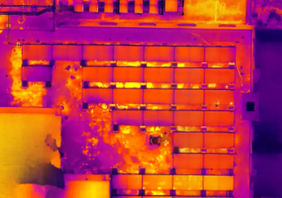
Thermal drones, equipped with high-resolution cameras and thermal sensors, detect issues invisible to the naked eye. When flown by licensed pilots with GIS expertise, they deliver precise, actionable data. Here’s what they offer:
Thermal Imaging: Sensors detect heat anomalies, like warm spots from water leaks or cold areas from insulation gaps, pinpointing problems in roofs, walls, or HVAC systems. Studies in building diagnostics show thermal scans identify energy inefficiencies missed by manual methods.
High-Resolution RGB Imagery: Detailed orthoimages, stitched with centimeter-level accuracy using Real-Time Kinematic (RTK) systems, map entire properties, providing clear records for maintenance or insurance claims.
3D Mapping: Using photogrammetry or LiDAR, drones create 3D models to assess structural integrity or track construction progress, reducing errors by up to 90%, per industry research.
Speed and Scale: A thermal scan of a large commercial property takes under two hours, compared to a full day for manual inspections, saving labor and equipment costs.
These capabilities allow facility managers to act proactively, addressing issues before they escalate into costly repairs or operational disruptions.
Why Professional Drone Services Outshine DIY
Many businesses own consumer drones, like the DJI Mini, thinking they’re enough for inspections. While these are great for basic photos, they lack the advanced sensors and expertise needed for commercial-grade work:
Equipment Limitations: Consumer drones often miss thermal imaging or RTK accuracy, critical for detecting hidden issues or producing precise maps.
Expertise Gaps: FAA Part 107 certification and GIS training are essential to navigate airspace, process data into orthomosaics or 3D models, and deliver audit-ready reports. Untrained staff may capture footage but struggle with actionable insights.
Efficiency Trade-Offs: DIY flights require training, maintenance, and hours of data processing. Professionals deliver processed reports in under 24 hours, freeing up your team.
For example, a New Jersey logistics facility missed a small roof defect during a DIY drone inspection, leading to water infiltration, HVAC strain, and $200,000 in repairs. A professional thermal scan, costing around $5,000, could’ve caught the issue early, saving six figures.
Compliance and Ethical Considerations
Commercial drone operations require strict adherence to FAA Part 107 rules, covering airspace, safety, and reporting. Unlicensed flights risk fines starting at $1,000 per violation, plus liability for damages or injuries. Professional services secure airspace approvals, carry specialized insurance, and ensure compliance with local regulations, reducing your risk.
Ethical operations are equally important, especially for properties near sensitive ecosystems. Drones can disturb wildlife, like birds or mammals, if flown too low or during breeding seasons. Research recommends altitudes above 100 meters and quieter electric models to minimize stress, noting drones often have a lower ecological footprint than ground crews. Responsible operators prioritize these guidelines, ensuring projects align with environmental stewardship. Look for upcoming posts on our blog exploring drone-wildlife interactions and eco-friendly practices.
Benefits for Commercial Property Management
Professional thermal drone services deliver clear advantages:
Cost Savings: Early detection prevents expensive repairs, with studies showing a single scan can save tens of thousands by catching leaks or inefficiencies.
Enhanced Safety: Drones eliminate risky climbs, reducing injury risks and potentially lowering insurance costs, as falls account for a significant portion of workplace incidents.
Actionable Insights: Processed data, like thermal reports or 3D models, supports maintenance planning, insurance claims, or regulatory audits.
Environmental Responsibility: GIS-trained pilots monitor ecological impacts, like erosion near construction sites, while adhering to wildlife-friendly protocols.
These benefits require expertise beyond owning a drone, ensuring properties stay efficient and sustainable.
Boost Your Visibility with Drone Services
Few property management firms promote thermal drone inspections online. Using keywords like “thermal drone property scans” or “aerial facility monitoring” can improve your SEO, helping clients find you first. Early adoption highlights your commitment to innovation, setting you apart in a competitive market.
Suave Droning: Precision with Purpose
Ready to protect your commercial property? Professional UAV services with FAA-licensed pilots and GIS expertise deliver the data you need to stay ahead. At Suave Droning, we use RTK-equipped drones, thermal imaging, and LiDAR across Pennsylvania, New Jersey, and New York to provide precise, actionable insights. Our reports support maintenance, compliance, and cost savings while prioritizing ethical operations that minimize environmental impact for our clients.
We’re offering complimentary thermal scans for three commercial properties in PA and NJ as part of a case study. Contact us to secure your spot and see the difference.
📩 Email: [email protected]
📅 Book an introductory call here.